A couple of months ago I read “A Hoxton Childhood”, A S Jaspers memoir of growing
up around the time of the First World War, close to my local area.
The area back then was extremely poverty stricken, but I’m
not going to hold forth on how fashionable and well-heeled the area is now,
because that Nathan Barley part of Hoxton is quite small. The rest of it, to
the north, is still an area of council housing estates and high unemployment
rates, and that’s where A S Jasper grew up.
Anyway, as a child, he and his family moved around a lot,
and he mentions most of the places he lived at or his father drank in. So I set
off one day to visit them, all being within a mile or two of where I live.
There was a lot that wasn’t there anymore, mainly the result of the devastation
that happened to the east end, during bombing raids in both world wars. But I
used old maps where needed to try and figure out where things would have been.
Only of vague semi interest if you’ve read the book, I guess, but anyway.
The first home the author mentions is on Canal Road, off
Hyde Road. Canal Road is still there, renamed Orsman Road. He doesn’t mention
the actual address on this road, but I doubt it’s there anymore, as most of the
buildings are after the time of the books setting.
The first pub mentioned is the Kings Arms on Hoxton Market. It’s still there, but is now a Nigerian
restaurant.
The next home of the author mentioned is 3 Clinger Street.
This doesn’t exist anymore, except in the name of one of the buildings in this 1950s housing scheme. Clinger Court, on the Hobbs Place estate.
Looking at old maps, I think this is area of garages is probably the remnants Clinger
Street.
The next location mentioned is Wilmer Gardens, where he goes
with his father to pay his respects to a dead child. The road is still there,
partially, but none of the original buildings, replaced by an estate called the
Whitmore. I guess this is the rough location mentioned in the book.
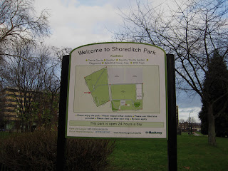
The next home the author lived in is Salisbury Street, just
off the New North Road. This whole area is completely gone, and is now
Shoreditch Park, where I take my son cycling. This park used to be tenements,
destroyed in the war. I think some of the park paths still follow the lines of
the old roads, and judging by relative positions on old maps, this is where
Salisbury Street was. There was a Time Team special, “Buried by the Blitz”
where they excavated in Shoreditch Park to uncover the damage done in the Blitz
to this area - http://www.channel4.com/programmes/time-team-specials/episode-guide/series-211/episode-2
Pimlico Walk
Bridport Arms, at 67 Bridport Place, is another pub that his
father frequented. Again, Bridport place is still there partially, but is
intersected by Shoreditch park. No 67 would have been on the right of this picture, in what is now parkland, opposite the cream tenbements on the left.
Ebeneezer Buildings, 1-5 Rotherfield Street
Another house the family move to is 15 Loanda Street. Again, all the original buildings are gone, replaced by council housing, but the street name survives.
Yet another house the family moved to is Scawfell Street off the Hackney Road. Two houses here, the first one on the road, above a dairy, which I assume is now this Tesco Metro, and his friends house at number 10 which is still intact.
Whiston Street Gasworks is now a park, although you can tell it's industrial origins in the high brick park walls.
Golden Lane
Featherstone street
Shepherdess Walk
Great Eastern St Arch. The actual overhead train line has been knocked down, but the uprights remain. Very apt graffiti as it is here that the family slept when they were homeless, along with tens of other fasmilies.


